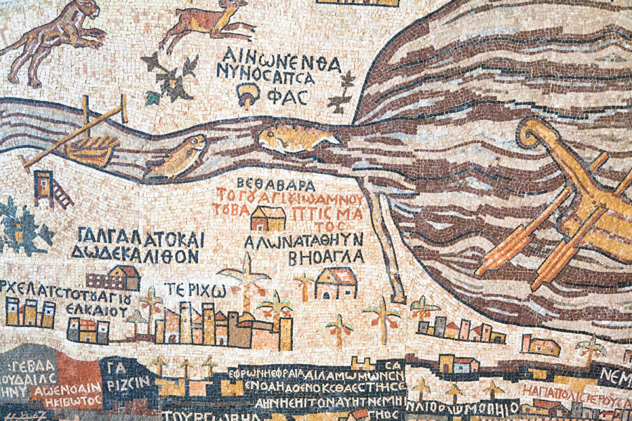
Madaba and its Map

More than a million pieces of colored stone and glass lie on the floor of a church in the Jordanian city of Madaba. This unique art treasure was designed in the middle of the 6th century, located in the Greek Orthodox Church of St George which has been built over it. The original map is 15.5 by 5.5 meters covering an area from Lebanon in the north to the Nile delta in the south. It is the one of the most accurate maps of the Holy Land from ancient times. Uniquely, the map is oriented towards the east with the Jordan river flowing across the map from left to right.
About 150 inscriptions in Greek name various biblical events and locations using colored stones and glass, such as Jericho, Jacob’s Well, the Oak of Mamre at Hebron, John’s baptism of Jesus, and the allotments of the 12 tribes of Israel. The map’s dominant focus is on the city of Jerusalem, presenting its walls, gates, main streets and specific buildings, including the Church of the Holy Sepulchre.
The purpose of map is not known but several suggestions are given:
- As an aid for pilgrims making their way to the holy places.
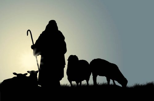
- As a representation of Moses’ vision of the Promised Land as he viewed the Promised Land from the top of nearby Mount Nebo.
- To provide a spiritual experience for worshippers during their services as it was situated on the floor of a church.
More emphasis is placed on the Church of the Holy Sepulchre than on Old Testament locations, focusing more on the message of salvation.
Madaba the town was an important town in the early centuries of the Christian era. But it was destroyed by an earthquake in 746 AD and it lay abandoned until the early 1880s. Now Madaba is the 5th largest city in Jordan.
(ref: seetheholyland.net)
Mt. Nebo

Mount Nebo, located in western Jordan is 820 meters high, looking down 1220 meters over the nearby Dead Sea. Jordan-Israel Border Crossing. About 3,500 years ago Moses stood on the summit of Mount Nebo, while viewing the Promised Land. But like most of the Israelites that came out of Egypt Moses also died without being allowed to enter the land promised to Abraham. Deuteronomy 34:5-6 tells of Moses’ death and burial. Moses led the people of Israel for 40 years. Interestingly though, Moses did eventually enter the Promised Land (see Luke 9:28-36).
From this view, on a clear day, people can see the same panorama Moses viewed. This includes the Dead Sea, the Jordan River valley, Jericho, Bethlehem and the distant hills of Jerusalem.
(ref: seetheholyland.net)
Jordan – Allenby Bridge Crossing:
This famous bridge is also known as the King Hussein Bridge. In 1918 General Edmund Allenby built his bridge over the remnants of an Ottoman era bridge. It was destroyed in 1946, and again during the Six Day War in 1968 and replaced with a temporary structure. In the 1990s the Israel-Jordan peace treaty allowed for the new modern bridge to be built that is still in use today.
Beth She’an

Beth She’an is one of the most incredible archaeological sites in Israel. Out has some of the best-preserved ruins in the Middle East. It was the location of one of the most ghoulish events in the Bible. King David, who succeeded Saul as king, wrote a lament over the tragedy, with the recurring line “How the mighty have fallen” in 2 Samuel 1:17 – 27.
Beth She’an is about 13 km south of the Sea of Galilee. During the Roman period it was the leading city of the Decapolis. Excavations have revealed a thriving city with a 7,000 seat theater; 6,000 seat amphitheater for gladiator performances; a huge bath and gym complex with swimming pool; public toilets with running water; a Roman basilica and administrative centre; and a nymphaeum. Christians and Muslims lived together until the disastrous earthquake in 749 AD.
(ref: seetheholyland.net)
Sea of Galilee

The Sea of Galilee has changed relatively little since Jesus walked on its shores and called four fishermen as his disciples. This picturesque lake is set among the hills in northern Israel. It has also been called the Sea of Tiberias and the Lake of Gennesaret and (in Hebrew). It is both fed by the Jordan River and drained by it, serving as Israel’s main water reservoir.
In Jesus’ time its main industry was fishing. Jesus’ ministry in Galilee was often located in the fishing town of Capernaum. Much of the life of Jesus in the Gospels tells of His time in and around this beautiful lake. And it is the place where He came back and met Peter after the resurrection.
Sudden storms, as seen in the Gospels, are common on the Sea of Galilee because it lies low in the valley, surrounded by hills.
In 1986, the remains of an ancient fishing boat were found in the lakebed. It was old enough to have been on the water in the time of Jesus and his disciples. Dubbed the Jesus Boat, it is now on permanent display at the lakeside Kibbutz Ginosar.
This place, Kibbutz Ginosar, is where we will spend the next’s three nights. A kibbutz (in Hebrew: “gathering, clustering”) is a collective community in Israel that was traditionally based on agriculture. Today, farming has been partly supplanted by other economic branches, including industrial plants and high-tech enterprises. Kibbutzim began as utopian communities, a combination of socialism and Zionism. In recent decades, many kibbutzim have been privatized and changes have been made in the communal lifestyle. A member of a kibbutz is called a kibbutznik
Related Biblical References:
- Numbers 20:8-12; Deut. 32:48-52; 1 Cor. 10:4; Exodus 17:6; Heb. 7:27 – Moses’ sin and tragic consequences.
- Deut. 34:1-12 – Moses last days, on Mt. Nebo
- Luke 9:28-36 – Moses meets with Jesus
- Judges 1:27 – Canaanites of Beth Sh’ean
- 1 Sam. 31:1-13; 2 Sam. 1:17-27 – The death of Saul; Lament of David
- Luke 5:1-11 – Fishing for men